Welcome to the Cumulus Support forum.

Latest Cumulus MX V3 release 3.28.6 (build 3283) - 21 March 2024

Cumulus MX V4 beta test release 4.0.0 (build 4019) - 03 April 2024

Legacy Cumulus 1 release 1.9.4 (build 1099) - 28 November 2014
(a patch is available for 1.9.4 build 1099 that extends the date range of drop-down menus to 2030)

Download the Software (Cumulus MX / Cumulus 1 and other related items) from the Wiki

Fire Weather, a new approach

Talk about anything that doesn't fit elsewhere - PLEASE don't put Cumulus queries in here!
User avatar
HansR
Posts: 5954
Joined: Sat 20 Oct 2012 6:53 am
Weather Station: GW1100 (WS80/WH40)
Operating System: Raspberry OS/Bookworm
Location: Wagenborgen (NL)
Contact:

Re: Fire Weather, a new approach

Post by HansR »

That's a prediction of 25+ mm for Christmas @Phil. I assume that would be the equivalent of a White Christmas in the Northern Hemisphere.
You have no idea about the message frequency Australia and NSW is getting in my twitter line and news threads. And I am not only talking about the bias I get from cookies and algorithms. The newspapers, journals etc... are really focussed on what is happening down south.
Hope for Australia the prediction becomes true. Some Christmas Carol that would be. :D :!:
You do not have the required permissions to view the files attached to this post.
Hans

https://meteo-wagenborgen.nl
CMX build 4017+ ● RPi 3B+ ● Raspbian Linux 6.1.21-v7+ armv7l ● dotnet 8.0.3
Phil23
Posts: 884
Joined: Sat 16 Jul 2016 11:59 pm
Weather Station: Davis VP2+ & GW1000 (Standalone)
Operating System: Win10 Pro / rPi Buster
Location: Australia

Re: Fire Weather, a new approach

Post by Phil23 »

Had the opportunity to drive thru the Fire grounds on Friday.

Very interesting observations to be made.

There are large areas of destruction, but most surprising is the amount of volatile fuel remaining.
This is particularly in the areas where back burning was carried out in attempts to limit the spread.

Conservatively 75% of the ground fuel remains in many areas & still a critical mass.
Due to the very strict guidelines enforced, the height of the flame front in a back burn operations needing to not exceed much more than a metre.
Trouble is now though that the build up has become so excessive, the time of year is totally wrong, and the safe low intensity burns are almost impossible to carry out.
https://www.rfs.nsw.gov.au/__data/asset ... urning.pdf

So essentially what I saw was small patches cleared at the edges of the field, that were more or less put out as quick as they were created, leaving an abundance of fuel behind for future events.

Any of the Tea Tree & other Native brush in the 1m height range remained untouched.

This is a sample of the fuel I took from the area a few weeks back, when we all knew the inevitable was coming.
10l bucket full from less than 1 square foot; 450g; 6kg to the sq metre; or 13 buckets of the same.
Floor Fuel.jpg
I've been intending to dispose of it, but it has sat there to ponder & refer to data & publications available.

But yesterday I carried out a very benign experiment on it which only highlighted the danger of it's presence.
Simply tipped in on the lawn & observed it with a thermal camera; result were more eye opening than I expected.
IMG26.jpg
IMG29.jpg
IMG30.jpg
IMG32.jpg
IMG37.jpg
Spot temperatures of the content in places exceed 75°C, basically in line with the black bitumen yesterday,
and still not a full sunlight day.

Issue now is that this is difficult to reduce due to changes in management practices Nation wide over the past 40 years.

Interesting summary of the fuel present in NSW is listed here.

https://www.rfs.nsw.gov.au/__data/asset ... eet-V8.pdf

Csiro publications state that most ground cover fuel has now reached peak levels & is being maintained at that,
while the sub 2m living & dead thicket continues to increase.
You do not have the required permissions to view the files attached to this post.
:Now: :Today/Yesterday:

Image

Main Station Davis VP2+ Running Via Win10 Pro.
Secondary Stations, Ecowitt HP2551/GW1000 Via rPi 3 & 4 Running Buster GUI.
:Local Inverell Ecowitt Station: :Remote Ashford Ecowitt Station:
Phil23
Posts: 884
Joined: Sat 16 Jul 2016 11:59 pm
Weather Station: Davis VP2+ & GW1000 (Standalone)
Operating System: Win10 Pro / rPi Buster
Location: Australia

Re: Fire Weather, a new approach

Post by Phil23 »

HansR wrote: Sat 21 Dec 2019 4:54 pm That's a prediction of 25+ mm for Christmas @Phil.
Yes, predictions are for some storms, which is not uncommon around the Christmas/New Year period.
Usually short & intense in that period, clearing up in either hours or days.

Over the past 35 years we've generally spent this period camping in Bush areas & the wet weather is generally never set in enough to put us off.

One that slipped my mind in relation to the previous post about the floor fuel was that that sample I looked at yesterday had spent Friday afternoon sitting under the sprinkler for an hour or more & was soaking in water Friday evening before I drained the tray it sat in.

By Mid-Day Saturday it was again totally crisp.

Phil.
:Now: :Today/Yesterday:

Image

Main Station Davis VP2+ Running Via Win10 Pro.
Secondary Stations, Ecowitt HP2551/GW1000 Via rPi 3 & 4 Running Buster GUI.
:Local Inverell Ecowitt Station: :Remote Ashford Ecowitt Station:
User avatar
HansR
Posts: 5954
Joined: Sat 20 Oct 2012 6:53 am
Weather Station: GW1100 (WS80/WH40)
Operating System: Raspberry OS/Bookworm
Location: Wagenborgen (NL)
Contact:

Re: Fire Weather, a new approach

Post by HansR »

@Phil:
Thanks for the elaborate messages on your finds!
But I do have difficulty to understand what exactly you are trying to say here. Yes, it's hot, that is clear. But it is far from autoignition temperature so what is exactly the point?

Thanks anyway for the links about Standards for low intensity bush fire hazard reduction burning (for private landholders) and the Comprehensive Vegetation Fuel Loads. Clearly you worry about the fuel loads in the forests which may be too high. But I would like to counter argue here that it only holds for the APZ, the Asset Protection Zone, which forces the 10/50 Vegetation Clearing (a regulation which btw is similar to the regulations used in Southern Europe). The regulation itself is more or less an acknowledgement of the existence of bushfires and the impossibility to prevent those.

But don't think, there is any chance of clearing forests in general of their litter layer or dead wood content. NSW has 2 million hectares of standing forests. Unless you cut them or burn them all, they have been and will be there longer than humanity. Litter and dead wood is part of those forests. Burning or clearing them will kill them and all living things within leaving NSW barren.

So yes, as long as it's about the 10/50 clearing, I agree, if you want to extend the clearings beyond that, it gets also beyond the scope of this meteo forum and needs to be discussed on it's own account with your RFS NSW.

Now shutting down for the holidays, back in the new year. Hope it stops burning down under. Best wishes to everybody. :)
Hans

https://meteo-wagenborgen.nl
CMX build 4017+ ● RPi 3B+ ● Raspbian Linux 6.1.21-v7+ armv7l ● dotnet 8.0.3
Phil23
Posts: 884
Joined: Sat 16 Jul 2016 11:59 pm
Weather Station: Davis VP2+ & GW1000 (Standalone)
Operating System: Win10 Pro / rPi Buster
Location: Australia

Re: Fire Weather, a new approach

Post by Phil23 »

HansR wrote: Sun 22 Dec 2019 10:56 am But I do have difficulty to understand what exactly you are trying to say here. Yes, it's hot, that is clear. But it is far from autoignition temperature so what is exactly the point?
Auto ignition is not an issue, but preheating of volatile fuel is.
Discussed this over lunch yesterday with a few friends.
One being on the Firefighting team & was in the fields till 2:30am, before the pre-arranged lunchtime meet.
He recounted Saturday afternoons events & the volatility of a patch of small spot fires & their difficulty in containing their increase.
Clearly you worry about the fuel loads in the forests which may be too high.
That is the general consensus among land holders. They all point to the past 30 years plus of changes in management practices.
But don't think, there is any chance of clearing forests in general of their litter layer or dead wood content. NSW has 2 million hectares of standing forests. Unless you cut them or burn them all, they have been and will be there longer than humanity. Litter and dead wood is part of those forests. Burning or clearing them will kill them and all living things within leaving NSW barren.
There in lies the problem.
There is simply no magical way to return the forests to the state they were in from the 1770 to 1980's period & before.
It will take a lot of change & roll back of changes to have our forests in their Native state again.

Locking them up hasn't worked, most parties closely involved totally agree.

Ironically, the grazing stock that previously helped maintain these areas are also locked out, returning it to the native animals.
Catch is the Natives, Kangaroos etc are no longer interested in grazing here, as they have much more attractive Crops & Pastures just down the road,
or over the fence to be a bit more correct. It's a 5 Star Restaurant to them, so they simply jump fences.
So yes, as long as it's about the 10/50 clearing, I agree, if you want to extend the clearings beyond that, it gets also beyond the scope of this meteo forum and needs to be discussed on it's own account with your RFS NSW.
Yes it's all about correct management & actually preserving our forests, not simply levelling them.
And yes, I've had many discussions ranging from property holders to local RFS members & management.
All sight the fundamental problem as the "locking Up" as it's most commonly referred to as.

Most interesting chat was one I had back in May of this year, following the pre-election "Meet the Candidates" forum.
We heard them all speak on various topics; but my Uncle (Farmer & Grazier of 60+ years), had the opportunity to sit with the local sitting member at the bar & chat for an hour over a few beers.

This man totally understood my Uncles views, agreeing with many, having a Rural background himself.
What was even more eye opening was his ability to quote Legislation Acts & Section numbers that were counter productive to both Primary Industry & Environment.
He is both experienced & high profiled within the Government, to the point of holding the position of Deputy Prime Minister.

One of the biggest issues he sighted was departmental submissions numbering up to 1000 in pages that could simply not be adequately reviewed before passing into Legislation.
Now shutting down for the holidays, back in the new year. Hope it stops burning down under. Best wishes to everybody. :)
Ditto the above to all, with best wishes.
With some luck we might just get rain.

Cheers.
:Now: :Today/Yesterday:

Image

Main Station Davis VP2+ Running Via Win10 Pro.
Secondary Stations, Ecowitt HP2551/GW1000 Via rPi 3 & 4 Running Buster GUI.
:Local Inverell Ecowitt Station: :Remote Ashford Ecowitt Station:
hills
Posts: 690
Joined: Sat 26 Dec 2009 8:52 am
Weather Station: Fine Offset WH1091
Operating System: Raspbian Buster
Location: Crafers, South Australia
Contact:

Re: Fire Weather, a new approach

Post by hills »

Hi Hans, I'd thought I'd give you a bit of local info regarding our location and how I think it will affect the predictions of the FWI for my station.

South Australia is known as the driest state in the driest continent (although lately Phil23 in NSW might be able to steal that label) and in SA the hot summer winds that cause bushfire danger typically come from the north, over central Australia, thus they are very hot and dry winds. Southerlies come from over the sea and are usually cold and damp winds.

However we are lucky here as our house is located on a south facing hill. This means 1 - we are protected by the hill from hot northerlies and 2 - if there is a fire it burns downhill to us, therefore much slower. In fact often when we have a hot northerly my weather station reports a southerly due to the impact of the hill as below.

Image

In short - we have a micro-climate here different to the rest of the area where the weather prediction covers, so I believe our place will always report a lower risk after the day compared to the prediction.

However this actually makes your software even more useful to me as I want to know the actual fire danger here at my house, not the rest of my area (as that is covered by the BOM), for example yesterday was predicted to be catastrophic both by your software and by Bureau of Meteorology but after the fact, your software only reported as "575 - very high", which I believe is correct for my specific location. (although don't get me wrong, this won't cause complacency with us, I have over 20 years experience in our volunteer fire service so I know every house is under threat from flying embers and we have a very well thought out bushfire action plan ;))

Thanks again for the effort you have put into this, it is excellent software!! :)
User avatar
HansR
Posts: 5954
Joined: Sat 20 Oct 2012 6:53 am
Weather Station: GW1100 (WS80/WH40)
Operating System: Raspberry OS/Bookworm
Location: Wagenborgen (NL)
Contact:

Re: Fire Weather, a new approach

Post by HansR »

@hill:
Hi Phil (two sites in Australia and both owners named Phil!),
Yes, locality matters. It is very difficult for me to give a validity range for the pwsFWI value, but I always give 50 km (on the map I draw a 25 km circle around the given location). Sea influence (or large water area's like the Great Lakes of Komoka) definitely do count and if you are in a valley in hills or low mountainous area the effects you show start being important. Impossible to predict for me.

But, I claim the technique I use is universal so if you understand what the pwsFWI says, it becomes much easier. Wet wood does not burn, dry wood does. Therefore I use the type of indication which uses VPD (Vapour Pressure Deficit; see here and here section: Current Status).

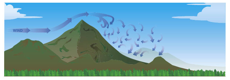
The last link makes clear it is about the drying conditions which form the essence of the pwsFWI. And those conditions are indeed heavily dependent on local situation. The turbulence you describe behind the mountain, may effectively hold the air locally while the upper layers slide away. A package which remains locally is called an Eddy and it is shown in the figure below (source):
rotor_cloud.png
Now as the Eddy stays more or less in place, turning around, it picks up moisture but only up to a certain level. So there is much less drying of timber than it would be with a continuously flow of dry northern air in your case. This holds until the Eddy is broken by changing wind direction and/or heavier turbulence. When wind is coming from sea, the moisture content will be higher already and much closer to saturation so the wood does not dry as quickly. In general, when the forest is still closed and able to maintain its own internal climate - a dampening effect of a closed forest - a mountainous (your) weather station will measure a higher RH than predicted in general for the surroundings. And added to that, the wind prediction and measurement will differ as well. BTW: wind measurement has more or less proven to be difficult for amateur meteo enthusiasts because of the standards of measurement rarely can be met and often are much lower than predicted.

So in general: yes it may very well be that you station gives a much more local indication than the global warning map of South Australia (see here and here). But at a first glance it appears that the pwsFWI gives roughly the same warning level as the Bureau of Meteorology (BoM). I am very happy with that. In NSW pwsFWI appears to be one class higher than the BoM gives.

And BTW: I am always very surprised the BoM warning level changes so fast in Australia. I had some exchanges about this with the other Phil. In general, as pwsFWI is about the dryness of the fuel, it will only really descend with water so : rain or a high RH because that will reverse the drying of the fuel (wood). The process of absorbing / releasing water from wood is typically not something which is a fast process. So in my opinion in one day going from red/purple warning level to yellow or even blue is in my opinion not good. It seems to be too much driven by wind.
You do not have the required permissions to view the files attached to this post.
Hans

https://meteo-wagenborgen.nl
CMX build 4017+ ● RPi 3B+ ● Raspbian Linux 6.1.21-v7+ armv7l ● dotnet 8.0.3
Phil23
Posts: 884
Joined: Sat 16 Jul 2016 11:59 pm
Weather Station: Davis VP2+ & GW1000 (Standalone)
Operating System: Win10 Pro / rPi Buster
Location: Australia

Re: Fire Weather, a new approach

Post by Phil23 »

hills wrote: Mon 30 Dec 2019 11:08 pm In short - we have a micro-climate here different to the rest of the area where the weather prediction covers,
Have always thought the same applied here.
We seem to be in a crater on the edge of the Tablelands.

It was very apparent the first time I came across a 3D raised relief map of Australia.

Visible too in an elevation profile.
Capture.JPG
You do not have the required permissions to view the files attached to this post.
:Now: :Today/Yesterday:

Image

Main Station Davis VP2+ Running Via Win10 Pro.
Secondary Stations, Ecowitt HP2551/GW1000 Via rPi 3 & 4 Running Buster GUI.
:Local Inverell Ecowitt Station: :Remote Ashford Ecowitt Station:
User avatar
HansR
Posts: 5954
Joined: Sat 20 Oct 2012 6:53 am
Weather Station: GW1100 (WS80/WH40)
Operating System: Raspberry OS/Bookworm
Location: Wagenborgen (NL)
Contact:

Re: Fire Weather, a new approach

Post by HansR »

We just had the passing of the year and I wish you all the best.

Hope the misery of the fires will improve down under. Love the exchange, learning and appreciation with all of you. It's a small world and there is only one of it.

And yes @Phil, I think you live in a similar situation as Phil 😉
Hans

https://meteo-wagenborgen.nl
CMX build 4017+ ● RPi 3B+ ● Raspbian Linux 6.1.21-v7+ armv7l ● dotnet 8.0.3
hills
Posts: 690
Joined: Sat 26 Dec 2009 8:52 am
Weather Station: Fine Offset WH1091
Operating System: Raspbian Buster
Location: Crafers, South Australia
Contact:

Re: Fire Weather, a new approach

Post by hills »

Thanks Hans, same to you! :D

And good luck to you Phil, I have been working up in Grafton recently and feel as if I've taken up smoking again ;) You certainly seem to be copping the worse of it up there lately!
User avatar
HansR
Posts: 5954
Joined: Sat 20 Oct 2012 6:53 am
Weather Station: GW1100 (WS80/WH40)
Operating System: Raspberry OS/Bookworm
Location: Wagenborgen (NL)
Contact:

Re: Fire Weather, a new approach

Post by HansR »

The really weird messages on twitter. This is how I receive Australia these days. It seems Mad Max is alive and kicking:
  1. Effects of fires in New Zealand
  2. State of Emergency in Sydney
  3. Absolutey fucked #Mallacoota (if it wasn't so bad you could laugh about him)
  4. And this one really touched me
    ------
  5. And meanwhile in Britain
This is beyond weather stations, computers and software.
This is about life as we know it and ecology.
This is 2020, we're burning up.
Hans

https://meteo-wagenborgen.nl
CMX build 4017+ ● RPi 3B+ ● Raspbian Linux 6.1.21-v7+ armv7l ● dotnet 8.0.3
Phil23
Posts: 884
Joined: Sat 16 Jul 2016 11:59 pm
Weather Station: Davis VP2+ & GW1000 (Standalone)
Operating System: Win10 Pro / rPi Buster
Location: Australia

Re: Fire Weather, a new approach

Post by Phil23 »

HansR wrote: Thu 02 Jan 2020 10:21 am This is about life as we know it and ecology.
This is 2020, we're burning up.
This all stems back to huge changes in land management back in 1995.
This is agreed upon by almost all that are on the land in a living basis.
Not those in offices or departments.

The patterns of management that went back 100's of years prior to settlement & fundamently the same for over 200 years after settlement were abruptly put on a different course.

Warnings have been there going back almost 30 years, just 7 years into its conception.

Now the situation has changed to the point of critical mass & the Solution has become much more complex.

I've mentioned association with my families property; they settled there in 1948, 72 years ago.
It had been maintained sustainably & in an environmentally friendly way for 50 years before changes were mad to how the owners could control it.

I also mentioned many of the hazard control measures carried out, including back burning operations I was involved with in my Teens.
In hind sight it is interesting what our control measures were...

Simply nothing more that a leaved branch or a corn sack to beat the edge of the fires perimeter if it wasn't proceeding in the right direction.
That in it's self is a true indication of the temperature & intensity. They were truly low temperature burns with only positive impacts on the ecology.

That is not the case today. Now on the occasions where reduction burns are permitted, substantial private firefighting equipment is required,
as the quantity of fuel that has been allowed to accumulate has exponentially increased to the point where maintaining a low temperature burn is near on impossible.


Sort of OT, But the other interesting thing is the Koala colonies on the 15,000 acres; There are 3 quite substantial ones.
These are known to be health & growing, but their precise location has not been allowed to become publicly know.

A mention years back about this was headed in the direction of external management & possible relocation, which the owners doubted would have any positive outcome.
I could walk right to one of those spots today, & I'm sure they are in a much safer situations than many of their cousins in the Nations Parks.

I'd often watched them leave their tree & wander across the ground to another, it's not an uncommon thing to witness out there.

But years back I also took one for a 250km+ ride in my car after finding him suck in thick undergrowth, slightly injured & totally exhausted.
(He seemed happy to wedge himself between the passenger's seat & the door pillar).

He was nursed back to health & survived & seemed to be enjoying his 24 hour vacation in our house waiting for the Wildlife Rescue to come.
:Now: :Today/Yesterday:

Image

Main Station Davis VP2+ Running Via Win10 Pro.
Secondary Stations, Ecowitt HP2551/GW1000 Via rPi 3 & 4 Running Buster GUI.
:Local Inverell Ecowitt Station: :Remote Ashford Ecowitt Station:
User avatar
HansR
Posts: 5954
Joined: Sat 20 Oct 2012 6:53 am
Weather Station: GW1100 (WS80/WH40)
Operating System: Raspberry OS/Bookworm
Location: Wagenborgen (NL)
Contact:

Re: Fire Weather, a new approach

Post by HansR »

Thank you @Phil, those are very interesting articles. Especially the one from 2019 (ABC) is a very elaborate well worked out article. Almost a university study overview.
Must say, that I am no fan of prescribed burning and bulldozing anti-fire corridors has only limited value: regarding at the fires today with its meteorology and humidity status, I doubt there would have been any measure to prevent fires like this: cinders and sparks flying around. Containment I think is the key.

The ABC article states:
The way a fire behaves and its severity is dependent on several elements, but can be narrowed down to three essentials: weather, fuel and topography.
[...]
The rate at which organic materials burns is directly related to its moisture content; the drier the fuel, the more fiercely it burns and the more intense the fire.
Topography can't be changed and neither can the weather. So humans focus on the fuel. But there is so much of it - the total burned area so far, is roughly the size of the Netherlands! In one month! - that you can't even think of really managing it without creating a desert. Warning and education as a prevention tool is not discussed.

Difficult. Not sure there is a real solution with a drought like this.
Dry wood burns, wet wood does not (or much, much slower)

Thanks again, great article!

NOTE: I saw you had 10 mm of rain yesterday. A drop on hot plate or a start of quenching the fires?
Hans

https://meteo-wagenborgen.nl
CMX build 4017+ ● RPi 3B+ ● Raspbian Linux 6.1.21-v7+ armv7l ● dotnet 8.0.3
Phil23
Posts: 884
Joined: Sat 16 Jul 2016 11:59 pm
Weather Station: Davis VP2+ & GW1000 (Standalone)
Operating System: Win10 Pro / rPi Buster
Location: Australia

Re: Fire Weather, a new approach

Post by Phil23 »

Lots of local activity down south right now.

I'm listening to it on scanner radio app.
The steam is Nsw Rfs northern tablelands.

You should be able to hear it yourself.
:Now: :Today/Yesterday:

Image

Main Station Davis VP2+ Running Via Win10 Pro.
Secondary Stations, Ecowitt HP2551/GW1000 Via rPi 3 & 4 Running Buster GUI.
:Local Inverell Ecowitt Station: :Remote Ashford Ecowitt Station:
Post Reply